

Author: Samuel Thornton
Title: New Draught of the Coast of Guinea and Brasile according to Mr Edwd Wrights Projection Vulgarly Called Mercator Chart.
Subtitle: By S. Thornton at the England Scot.d and Ireland in the Minories London
 Delivery policy
Our remailer uses DHL/Fedex at a fraction of the standard cost. Email us for a quote.
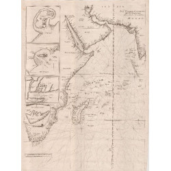
There is no record of prior sale of this chart by Samuel Thornton of the Mozambique channel and adjacent coastlines. The chart first was published in 1701 by Jeremiah Seller & Charles Price (1700-1705) in Part V of the English Pilot.
Samuel Thornton's imprint is retained on a copy of the chart at the New York Public Library and also at the Army & Navy Club Library Trust. The former example is included in pages of text from ‘Sea-Coasts of the Known Parts of the World’. The chart is also in an undated (possibly after 1720), incomplete copy of Part V of the English Pilot at the British Library.
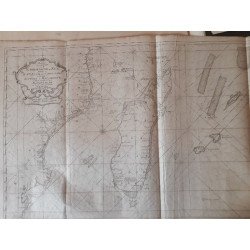
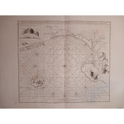
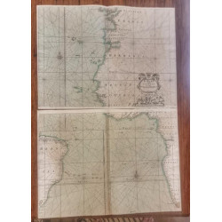
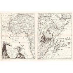
Drawn on Mercator’s Projection, the chart is of the Atlantic Ocean between 19° North and 42° South – there are separate northern and south scales of latitude, a device John Thornton had used – see Lot #1). The chart shows the coastline of Dutch Brazil and extends further south to the mouth of the Rio de la Plata. It shows the west African coast from about Cape Verde to the C Bona Esperasa (sic), i.e., The Cape of Good Hope. There are two longitude scales one with the prime meridian though Tenarife (sic) and one through the Lizard (the southern tip of Cornwall where a sliver of Earth’s mantle is exposed).
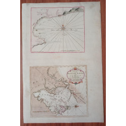
The chart includes an inset ‘Draught of the Island of Trinidada taken by Capt.n Edm.d Halley’ in April 1700, when the famous astronomer was ‘temporary captain’ of HMS Paramour, the Royal Navy gunship. An annotation on the inset records Halley' comment: ‘You may anchor on the west side of the island about a mile from the shore graduall (sic) soundings, here is good water but it is difficult to get into your boat, the land being very rocky. Halley’s visit to Trinidada (now Trinidade and Martim Vaz) was the basis of a failed British attempt in 1895 to claim sovereignty of Trinidade!
Samuel Thornton (1665 – 1715), worked in his father’s business which he continued after his father’s death in 1708. Samuel’s stock then passed to Richard Mount and Thomas Page who continued to publish some of the Thorntons’ maps, usually erasing the Thornton imprint. The Mount and Page families continued to publish throughout the eighteenth century.
The chart is printed on firm, lightly age-toned paper and there is vertical glue stain about the central join of the two sheets, with tiny dots of stain outside the plate line.
References: Map Collectors Series No. 61 # 278. Not in Tooley’s Collectors’ Guide to Maps of Africa or Norwich’s Maps of Africa.
Ortolja-Baird, L. The English Pilot, the Fifth Book, Africa, 1701–1792. IMCoS Journal of Spring 2014, pages 13-20.
Publisher: London, Seller & Price.
Dimensions: 56 x 47 cm
Date: 1701
Estimate: $ 2500 - $4000
Reserve: $2250
Author: Samuel Thornton
Title: New Draught of the Coast of Guinea and Brasile according to Mr Edwd Wrights Projection Vulgarly Called Mercator Chart.
Subtitle: By S. Thornton at the England Scot.d and Ireland in the Minories London
![Kaffersche Kust, Begrypende de Sardanje-Bay en de Caap de Bonne Esperanc [sic]](http://www.africanamaps.co.za/35-home_default/kaffersche-kust-begrypende-de-sardanje-bay-en-de-caap-de-bonne-esperanc-sic-.jpg)


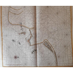

.jpg)