Author: Johannes II van Keulen
Title: Mosambique
 Delivery policy
Our remailer uses DHL/Fedex at a fraction of the standard cost. Email us for a quote.
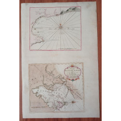
This rare chart of Mozambique Island and surrounds, now a UNESCO World Heritage Site, is from the 1753, so-called ‘secret VOC Atlas’, Part VI of the Nieuwe Lichtende Zee-Fakkel. The chart was produced by Johannes II van Keulen (1704-1755), hydrographer for the VOC and the grandson of the patriarch. Part VI was the pilot-guide for sailing between the Netherlands and the East Indies; Jan de Marre provided the text. The sale of only two examples of this chart have been recorded since 1985.
Now a UNESCO Heritage Site: Mozambique Island was a focal point for ‘navigation in the Indian Ocean, with the island playing a unique role in intercontinental trade from the 10th century. Its international historic importance relates to the development and establishment of Portuguese maritime routes between Western Europe and the Indian subcontinent.’
In the sixteenth century, the Portuguese established a port, the Fort São Sebastian and the adjacent Chapel of Nossa Senhora de Baluarte, with its Manueline vaulted architecture, now considered the oldest European buildings in the Southern Hemisphere. The island also became an important missionary centre, withstood Dutch attacks in 1607 and 1608 and remained a major post for the Portuguese, involved in the trade of slaves, spices, and gold.
To the north of the island, is van Keulen’s Cabo Zero peninsula, now Cabaceira Pequena. Van Keulen indicates the presence of a ‘kerk’ (church) and begrafplaas (cemetery). The church is Nossa Senhora dos Remédios, arguably the oldest surviving European building in the Southern Hemisphere. The cemetery still includes the tomb of Mussa bin Bique, the Arab sultan and Islamic scholar, from whom the name of the island and later of the entire nation of Mozambique, is derived. The graves are placed in such a position that they enjoy a clear view of the Island of Mozambique.
Cabaceira also has a mosque that was built in the 1400s, making it one of the oldest mosques in the world. To this day, locals draw water from the wells dug by Vasco da Gama in 1498. Van Keulen’s 'Santa Coele', with the annotation ‘Vissers Negery’ ('Negro Fishermen'), is now the Port of Lombo from which there is now a causeway joining the mainland to the island. To the east of Mozambique Island are the small, unpopulated islands of Goa, which now has a lighthouse, and Zena (sena).
This scarce, historically important chart has outline colour, is printed with very wide margins on firm paper (there are three very small areas of paper loss on the left margin) and is in near-fine condition.
References: Not in Norwich’s Maps of Africa, nor Tooley’s Collectors’ Guide to Maps of Africa, nor in the Map Collectors’ Series.
Publisher: Amsterdam, J. van Keulen
Dimensions: 56 x 50 cm
Date: 1753
Estimate: 3000-4500
Reserve: $2750
Author: Johannes II van Keulen
Title: Mosambique