Author: Johannes II van Keulen
Title: Paskaart van een Gedeelte van de Aethiopische-Zee, Strekkende van R. Sta. Lucia tot C. del Gado, Langs de Kusten van Suffalo en Mocambique, Bevattende Insgelyks 't Eiland Madagascar met Desselfs Onderhorige Eilanden
Subtitle:Te Amsterdam by Iohannes van Keulen. Zee Kaart en Boek verkoper op de hoek van de Nieuwenbrug steeg
 Delivery policy
Our remailer uses DHL/Fedex at a fraction of the standard cost. Email us for a quote.
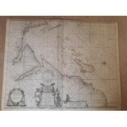
[Sea chart of a Part of the Ethiopian Sea; stretching from Rio St. Lucia to Cabo del Cado, along the coasts of Suffalo and Mozambique, also containing the island of Madagascar and its dependent islands.]
This chart of the western sector of the Indian Ocean is very seldom in the market. It is from the 1753, so-called ‘secret VOC Atlas': Part VI of the Nieuwe Groot Lichtende Zee-Fakkel by Johannes II van Keulen (1704-1755), hydrographer for the VOC and the grandson of the patriarch. Part VI was the pilot-guide for sailing between the Netherlands and the East Indies, with text provided by Jan de Marre. There is record of only two copies of this chart having been sold since 1985.
The Dutch National Archives has a coloured copy of this chart pasted to blue paper (NL-HaNA_4.VEL_215) and there is also an example in the National Library of Portugal (DC 668 A). The former example has XXVIII on the verso; our example does not.
The chart is drawn on the Mercator projection. It includes all of Madagascar, the Comoro Islands (Gasidsa Comoro, i.e. Ngazidja or Grand Comoro), Mohila, Anjoana and Mayota), the Mascarene Islands (Mauritius, Rodrigues and I. de Mascarenhas, i.e. Reunion) and prominently depicts the Cargados Carajos Shoals (St. Brandon).
The route of return voyage from the Spice Islands varied according to seasonal winds and storms and passed near to Rodriques, bypassing the Mozambique Channel. The chart identifies the Portuguese factories at Suffalo (Sofala), Mocambique Island with its Fort San Sebastian (‘Eiland and stad Mocambique’ at about 15°15’S on the chart). It identifies the mouth and triangular delta of the Zambesi River, named Cuama or Luaba River on the chart, the latter being a southern channel in the delta.
The sector of the sea route on the eastern coast of Africa and Madagascar was all-important for ships trading in spices, ivory and gold between Europe and the Far East. The sector on this chart extends from St. Lucia, in today’s northern KwaZulu Natal in South Africa, to Cape del Gado near the Kenyan border. This route through the Mozambique Channel could be avoided on the outbound voyage by following the faster Brouwer Route in the roaring forties.
The area included in this chart was also used by slave traders and pirates, with Antongatt, i.e. Antongil or Ranter Bay on Madagascar, and nearby St. Mary’s Island (Nosy Bohara), being particularly notorious, until about 1710, for its pirates and purportedly home of the free pirate colony (Libertalia) of about 1500 pirates and seventeen ships. The Pirate Round was a route used by pirates of the Caribbean to reach Madagascar where they would 'frequently careen and refit their ships on Madagascar and take on fresh provisions before proceeding onward toward their targets further north.'
The chart also includes the phantom islands of Juan de Lisboa, to the east of the southern tip of Madagascar, I dos Romeiros to its southeast and I. de Roquepriz to the Nnortheast of Madagascar.
Van Keulen included a small box of text in southern Madagascar explaining that the placenames were derived from the Portuguese and English. So, 'Ilha do Nascimento', on the south-east coast of Madagascar, was better known to the Dutch as Hollandse Kerkhof (Nosy Manitse, today), the ‘cemetery of the Dutch’: the burial ground of Dutch sailors during the 1595 voyage of Admiral Cornelis De Houten to the East Indies. Most had died of scurvy, which was relieved when the ships touched the eastern African coast, in and beyond the channel, where they received fresh fruit from the indigenous inhabitants.
An earlier edition of the chart with the same title and cartouche (NL-HaNA_4.VEL_215), extended only as far east as Reunion Island. This smaller chart is attributed to Johannes I van Keulen (one of the few charts not to claim his privilege). It has been dated 'before 1679', but it must have been published later because the chart also has the annotation on the discovery in 1682 of shoes near northwestern Madagascar by Firebrass, a slave trader. The later chart (in this lot) extended further east because of the route the VOC followed on the return voyage. Subsequently, French and English hydrographers would produce similar charts.
The example in this lot is uncoloured, printed on lightly age-toned, countermarked, light paper, not backed on to blue paper, and the fold lines have been preserved. The chart is in near fine condition.
References: Not in Norwich's Maps of Africa; nor Tooley's Collectors' Guide to Maps of Africa, nor, Map Collectors’ Series.
Bruijn, Jaap R. “Between Batavia and the Cape: Shipping Patterns of the Dutch East India Company.” Journal of Southeast Asian Studies 11, no. 2 (1980): 251–65.
Publisher: Amsterdam, Johannes II van Keulen
Dimensions: 87.5 x 49.0 cm
Date: 1753
Estimate: $3000 - $4000
Reserve: $2750
Author: Johannes II van Keulen
Title: Paskaart van een Gedeelte van de Aethiopische-Zee, Strekkende van R. Sta. Lucia tot C. del Gado, Langs de Kusten van Suffalo en Mocambique, Bevattende Insgelyks 't Eiland Madagascar met Desselfs Onderhorige Eilanden
Subtitle:Te Amsterdam by Iohannes van Keulen. Zee Kaart en Boek verkoper op de hoek van de Nieuwenbrug steeg