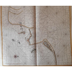
TOP MAP: Pas Caart van de Baay De Lagoa gelegen op de Cust van de Cafres tusschen 25 en 26 gr. Zuider Breedt. [sea chart of De Lagoa Bay located on the Kafir Coast between 25 & 26 degrees south].
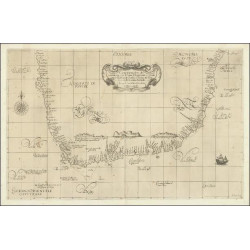
BOTTOM MAP: Mossel Baay in’t ligt bebragt door Johannes van Keulen. [Mossel Bay brought to light by Johannes van Keulen] 27 x 23 cm.
 Delivery policy
Our remailer uses DHL/Fedex at a fraction of the standard cost. Email us for a quote.
This small chart (28.6 x 25 cm) shows the Portuguese village and fort that the Dutch abandoned in 1730 due to many deaths from malaria. It also shows Olphant’s & Inhaqua (S Maria) Islands and the mouth of R Lagoa (Komati) and three smaller unnamed rivers entering the also unnamed Spiritu Santo estuary. This small chart is uncommonly in the market: three sold since 1985.
Mossel Baay in’t ligt bebragt door Johannes van Keulen. [Mossel Bay brought to light by Johannes van Keulen] 27 x 23 cm. The chart shows Robben Eylandt (Seal Island); Aankoment baatje (the landing place) and the Fontyn (spring) + building – the VOC (Dutch East India Company) emblem represents the company’s presence (the building, a grain warehouse) at Mossel Bay from 1734.
Meyer’s Hoff is shown a short distance inland of the central shore. It was a homestead built in 1730 by Esaias Meyer, to whom the farm was granted by VOC, after he helped shipwrecked sailors. He called his farm Hartenbos, ‘Hart en Bosch’ (deer and bush). Generations of Meyers were popular, generous host to many travelers to and from the hinterland via the Attaquas Kloof Pass. The chart of Mossel Bay was later redrawn by Alexander Dalrymple (1784) and also in numerous editions of the Oriental Pilot. This small van Keulen chart is also uncommonly on the market: two sold since 1985.
The primary chart shows the original fold lines. The chart is printed on light, mildly aged-toned paper. The insets are on different light-weight paper. The small chart of Lagoa has oxidized old colour of the inland area of the chart and Mossel Bay has a stain and repair outside the plate line top right.
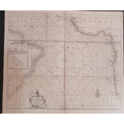
References: The Map Collectors’ Series, No. 61, # 174 (the two insets) and 61, #175 (‘Coast Saldanha Bay to Baay Nataal’). The insets are in Tooley’s Collectors’ Guide to Maps of Africa, p. 63. None of the charts is in Norwich.
Mossel Baay in’t ligt bebragt door Johannes van Keulen. [Mossel Bay brought to light by Johannes van Keulen] 27 x 23 cm. The chart shows Robben Eylandt (Seal Island); Aankoment baatje (the landing place) and the Fontyn (spring) + building – the VOC (Dutch East India Company) emblem represents the company’s presence (the building, a grain warehouse) at Mossel Bay from 1734.
Meyer’s Hoff is shown a short distance inland of the central shore. It was a homestead built in 1730 by Esaias Meyer, to whom the farm was granted by VOC, after he helped shipwrecked sailors. He called his farm Hartenbos, ‘Hart en Bosch’ (deer and bush). Generations of Meyers were popular, generous host to many travelers to and from the hinterland via the Attaquas Kloof Pass. The chart of Mossel Bay was later redrawn by Alexander Dalrymple (1784) and also in numerous editions of the Oriental Pilot. This small van Keulen chart is also uncommonly on the market: two sold since 1985.
The primary chart shows the original fold lines. The chart is printed on light, mildly aged-toned paper. The insets are on different light-weight paper. The small chart of Lagoa has oxidized old colour of the inland area of the chart and Mossel Bay has a stain and repair outside the plate line top right.
References: The Map Collectors’ Series, No. 61, # 174 (the two insets) and 61, #175 (‘Coast Saldanha Bay to Baay Nataal’). The insets are in Tooley’s Collectors’ Guide to Maps of Africa, p. 63. None of the charts is in Norwich.
Publisher: Amsterdam, Johannes van Keulen
Dimensions: 64 x 105 cm
Date: ca. 1753
Estimate: $3750 - $5000
Reserve: $3000
TOP MAP: Pas Caart van de Baay De Lagoa gelegen op de Cust van de Cafres tusschen 25 en 26 gr. Zuider Breedt. [sea chart of De Lagoa Bay located on the Kafir Coast between 25 & 26 degrees south].
BOTTOM MAP: Mossel Baay in’t ligt bebragt door Johannes van Keulen. [Mossel Bay brought to light by Johannes van Keulen] 27 x 23 cm.