

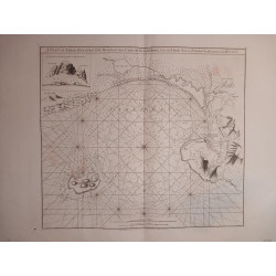
Title: A Draught of Cape Bona Esperanca
Subtitle: by John Seller Hydrographer to the King
 Delivery policy
Our remailer uses DHL/Fedex at a fraction of the standard cost. Email us for a quote.
Very few collectors have A Draught of Bona Esperanca, the scarce chart of the Cape of Good Hope by John Seller, the highly influential English hydrographer - there is record of only two copies sold since 1985. The chart was published by Seller in 1675 in both his Atlas Maritimus and his English Pilot (Third Part); it also appeared in the fifth part of the English Pilot, published in 1701 by Jeremiah Seller & Charles Price.
In 1703, John Thornton redrew the map, omitted Saldanha Bay and added a key to structures on the prospect of Cape Town (see Lot #11). The Thornton editions replaced Seller's Draught for decades until Mount and Page returned to the original map by Seller but erased his imprint.
Seller's distorted coastal outline of the chart was derived from one of the VOC charts of the coast from Saldanha Bay to False Bay; these charts are now at the Dutch National Archives (Nationaal Archief 4.VEL 168 and 4.VEL 169.35).
Table Bay was so named by Joris Spillbergen c. 1602, but Seller retained the original name of Saldinia Bay. Robben Island is named Penguin Island and False Bay, seemingly ignored for decades by the Dutch settlers, is unnamed. It was only in 1775 that Apres de Mannevillette published a much more accurate sea chart of the same region ('Plan du Cap de Bonne Esperance et de ses Environs'), but it included minimal information on the interior.
Olfert Dapper’s view of Cape Town (Cabo de Bone Esperanse, in Beschrijvinge der Afrikaanse Gewesten, 1668) was the model for Seller's vignette above the chart: the prospect of Cape Town, but with English toponyms, and the Dutch wood and mud fort depicted on a curtain.
The chart has outline colour, is printed on firm paper and is in near-fine condition – the top margin is very close to the plate line.
References: Tooley’s Collectors’ Guide to Maps of Africa, p. 104;
Map Collectors Series, No. 61 #248.
Seller’s Cape Bona Esperanca. Deliberate Dutch Disinformation? Maps in History; 2016; 56: 17 – 23.
Not in Norwich's Maps of Africa.
Publisher: London, John Seller
Dimensions: 54 x 44 cm
Date: 1675
Estimate: $3500 - $4500
Reserve: $2500
Title: A Draught of Cape Bona Esperanca
Subtitle: by John Seller Hydrographer to the King

![Kaffersche Kust, Begrypende de Sardanje-Bay en de Caap de Bonne Esperanc [sic]](http://www.africanamaps.co.za/35-home_default/kaffersche-kust-begrypende-de-sardanje-bay-en-de-caap-de-bonne-esperanc-sic-.jpg)