![Kaffersche Kust, Begrypende de Sardanje-Bay en de Caap de Bonne Esperanc [sic]](http://www.africanamaps.co.za/35-large_default/kaffersche-kust-begrypende-de-sardanje-bay-en-de-caap-de-bonne-esperanc-sic-.jpg "Kaffersche Kust, Begrypende de Sardanje-Bay en de Caap de Bonne Esperanc [sic]")
![Kaffersche Kust, Begrypende de Sardanje-Bay en de Caap de Bonne Esperanc [sic]](http://www.africanamaps.co.za/35-small_default/kaffersche-kust-begrypende-de-sardanje-bay-en-de-caap-de-bonne-esperanc-sic-.jpg "Kaffersche Kust, Begrypende de Sardanje-Bay en de Caap de Bonne Esperanc [sic]")
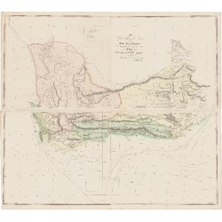
Ttitle: Nieuwe Naauwkeurige Land- en Zee-kaart, van het voornaamste Gedeelte der Kaffersche Kust, Begrypende de Sardanje-Bay en de Caap de Bonne Esperanc [sic] met alle des Zelfs Plantazien.
Subtitle: zeer Getrouwelyk Waargenomen en Afgetekend, to Nut der Geener Welke die Kust Trachten te Bevaaren
 Delivery policy
Our remailer uses DHL/Fedex at a fraction of the standard cost. Email us for a quote.
Nieuwe Naauwkeurige Land- en Zee-kaart, van het voornaamste Gedeelte der James Wyld Kust, Begrypende de Sardanje-Bay en de Caap de Bonne Esperanc [sic] met alle des Zelfs Plantazien. Zeer Getrouwelyk Waargenomen en Afgetekend, to Nut der Geener Welke die Kust Trachten te Bevaaren.
[New Accurate Land and Sea Map, of the Main Part of the Kaffir Coast, Including Saldanha Bay and the Cape of Good Hope with all the Plantations. Very Faithfully Observed and Signed, for the Benefit of Anyone Who Attempts to Navigate That Coast].
This anonymous and undated map is scarce, not well known and is important for both its historical record and its widespread influence on eighteenth century mapping of the Cape of Good Hope. It is arguably one of the most important landmarks in the mapping of the Cape of Good Hope and southern Africa.
Recent information has lifted some of the veil of mystery: Johannes Loots is the author of this c. 1698 land and sea chart that was described in detail in the IMCoS Journal of Spring 2014, pages 13-20.
Nieuwe Naauwkeurige Land- en Zee-Kaart is of considerable historical importance from a number of perspectives.
Johannes Loots (1665 - 1726) was a publisher of sea charts, who began his career as an apprentice to Hendrick Doncker. Loots later set up his own business in a shop on Nieuwebrugsteeg in Amsterdam.
This map has outline colouring, the imprint is dark and it is in fine condition.
References:
Roger Stewart, IMCoS Journal of Spring 2014, pages 13-20.
Norwich’s Maps of Africa: map #207 (mis-attributed to Ottens).
Not in Tooley's Collectors' Guide to maps of Africa or in the Map Collectors' Series
Publisher: Amsterdam, Johannes Loots,
Date: c. 1698
Dimensions: 40 cm x 58 cm.
Estimate: $7000-$9000
Reserve: $5500
Ttitle: Nieuwe Naauwkeurige Land- en Zee-kaart, van het voornaamste Gedeelte der Kaffersche Kust, Begrypende de Sardanje-Bay en de Caap de Bonne Esperanc [sic] met alle des Zelfs Plantazien.
Subtitle: zeer Getrouwelyk Waargenomen en Afgetekend, to Nut der Geener Welke die Kust Trachten te Bevaaren