Author: Mount and Page (John and then Saml Thornton)
Title: A Draught of Cape Bona Esperanca
 Delivery policy
Our remailer uses DHL/Fedex at a fraction of the standard cost. Email us for a quote.
This scarce chart is the final, third, state of the Thorntons’ re-engraving of the chart first published by John Seller in 1675 (see Lot #10). Over the past 35 years, only one prior sale of this state of the chart has been reported, and only one of an earlier state; there are two institutional copies.
The chart was engraved on copperplate by John Thornton (1641 – 1708), an engraver, hydrographer and publisher, one of the Thames School of Chart makers, who succeeded John Seller (c.1630-1697). The first state of Thornton’s chart was included in the 1703 edition of Part III of the English Pilot published by John Thornton and William Fisher.
John Thornton was one of a group who in 1676 initially assisted Seller with his business that was struggling financially. By 1679 the group had disintegrated with Thornton acquiring the rights to Seller’s English Pilot and Atlas Maritimus.
Thornton made numerous changes when he re-engraved Seller’s chart of the Cape of Good Hope:
In 1708, John's son, Samuel Thornton (1665-1715), inherited his father's cartographic assets. Samuel produced another edition of Part III of the English Pilot in 1711 and replaced his father’s imprint with his own.
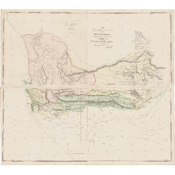
Samuel also added the toponym of the Bay of Falzo (False Bay) with its ‘Great Reef’ (i.e. Seal Island) and Blinde Klippin (blind, i.e. submerged rocks) – False Bay was increasingly being used as the winter anchorage at the Cape of Hood Hope (declared officially in 1743 by the Dutch East India Company).
Richard Mount and Thomas Page took over the Thornton business and stock. In this final, third state Mount and Page deleted the Thornton imprint from the Draught of Cape Bona Esperanca; it was published in 1734 in Part III and in 1743 in Part V of the English Pilot.
In ca. 1761 Mount and Page returned to the original Seller plate but also deleted his imprint.
This chart has light green outline colouring and very pale green wash in the ocean; it has very wide margins. There is a fold shadow in the upper half of the chart and there is a faint glue stain along the bottom quarter of the central join. Otherwise, the chart is in very good condition.
References: Tooley’s Collectors’ Guide to Maps of Africa, pages 101 & 104. Norwich’s Maps of Africa, #219. Not in the Map Collectors’ Series. Seller’s Cape Bona Esperanca. Deliberate Dutch Disinformation? Maps in History; 2016; 56: 17 – 23.
Publisher: London, Mount & Page
Dimensions: 53 x 43 cm
Date: 1734 or 1743
Estimate: $2500 - $3500
Reserve: $2000
Author: Mount and Page (John and then Saml Thornton)
Title: A Draught of Cape Bona Esperanca
![Kaffersche Kust, Begrypende de Sardanje-Bay en de Caap de Bonne Esperanc [sic]](http://www.africanamaps.co.za/35-home_default/kaffersche-kust-begrypende-de-sardanje-bay-en-de-caap-de-bonne-esperanc-sic-.jpg)