- Out-of-Stock


Title: To Captain Carmichael Smyth of the Corps of Royal Engineers who Obligingly Furnished Many of the Materials. This Chart of the Cape of Good Hope is Inscribed,
Subtitle: by his obedient and most humble servant A. Arrowsmith. Hydrographer to H.R.H. The Prince of Wales.
 Delivery policy
Our remailer uses DHL/Fedex at a fraction of the standard cost. Email us for a quote.
Full title: 'To Captain Carmichael Smyth of the Corps of Royal Engineers who Obligingly Furnished Many of the Materials. This Chart of the Cape of Good Hope is Inscribed, by his obedient and most humble servant A. Arrowsmith. Hydrographer to H.R.H. The Prince of Wales.'
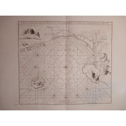
This is the first large scale map of the Cape of Good Hope (143 cm x 122 cm when joined)– it was drawn and engraved by Aaron Arrowsmith, the famous patriarch of a highly regarded family of British cartographers. This 1805 map was the most accurate printed map of the Cape of Good Hope at the time. It extends from approximately 30° to 37° South and 18° to 28° East of Greenwich. It includes considerable hydrographic and even oceanographic information: both a terrestrial map and hydrographic/oceanographic chart. This rare, scarce landmark map is arguably one of Arrowsmith’s finest cartographic productions in the scientific mapping of southern Africa.
Aaron Arrowsmith I based this large format map on sound, up-to-date, first-hand information. For the terrestrial topographic components of his map, he relied on information from Capt. James Carmichael-Smyth of the Royal Engineers, to whom he dedicated the map.Smyth had been responsible for mapping, coastal surveys and fortifications, and gained considerable knowledge of the interior of the colony.
However, Arrowsmith also drew heavily information he gleaned from John Barrow who had travelled extensively in the Cape Colony (1797 -1799) and produced his seminal map of the colony first published in 1801. Annotations on Arrowsmith's map on indigenous groups, animals, plants and crops all derive from Barrow. One annotaion is an obscure reference to the White Rhinoceros (at 30°S and 20° E) that had not yet been described to science (Kees Rookmaaker, of the Rhino Resource Center, discusses this here, on pages 7-9).
In the area west of Swellendam, the map also records, from Barrow, the extinction of the Blue Antelope (‘once in this part of the country’) – arguably the first cartographic record of the extinction of an animal species in South Africa.
There is also considerable hydrographic and oceanographic information with the latter including details on the Agulhas bank and current. This information was derived from the earliest and highly regarded oceanographic studies at the Cape conducted in 1777 by James Rennel, ’the Father of Oceanography’.
This large-format, remarkable map is truly a landmark in the scientific mapping of southern Africa. It is very seldom in the market (two recorded sales in the past 35 years). The map is uncoloured, printed on firm paper and in near-fine condition: there is some light offsetting and a few areas of light foxing.
References: Tooley’s Collectors’ Guide to Maps of Africa, p. 10; Map Collectors’ Series No 61. # 25. Not in Norwich's Maps of Africa.
Publisher: London, A Arrowsmith.
Dimensions: 71 x 61 cm x 4 double sheets
Date: 1805
Estimate: $7500 - $10000
Reserve: $5500
Title: To Captain Carmichael Smyth of the Corps of Royal Engineers who Obligingly Furnished Many of the Materials. This Chart of the Cape of Good Hope is Inscribed,
Subtitle: by his obedient and most humble servant A. Arrowsmith. Hydrographer to H.R.H. The Prince of Wales.

![Kaffersche Kust, Begrypende de Sardanje-Bay en de Caap de Bonne Esperanc [sic]](http://www.africanamaps.co.za/35-home_default/kaffersche-kust-begrypende-de-sardanje-bay-en-de-caap-de-bonne-esperanc-sic-.jpg)