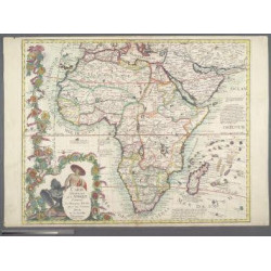
Africa. SUBTITLE: descritta dal P. M. Coronelli ; e dedicata all'Eccellenza del Signor gran contestabile Colonna gia VceRè d’Aragona, poi Vce Rè di Napoli. CHECK BOTTOM RIGHT
 Delivery policy
Our remailer uses DHL/Fedex at a fraction of the standard cost. Email us for a quote.
[Africa, divided into its parts according to the most modern information with the discoveries of the origin of the Nile … described by P. M. Coronelli; and dedicated to the Excellency of the highly ‘contestable' Lord Colonna, formerly Vice King of Aragon, then Vice King of Naples.]
This uncommon, beautiful and richly decorated uncoloured map of Africa describes inter alia the origin of the Blue Nile. The title cartouche is depicted on a drape surrounded by native animals. Drapery in the middle of the continent contains text describing the exploration and source of the Nile. To its right, Father Nile, reclines against a vessel from which water rushed onto the back of a (Nile) crocodile.
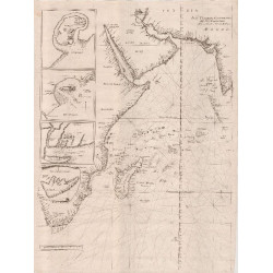
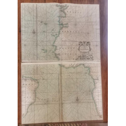
The map is drawn on four sheets, with the top and bottom of the left and right halves joined. The prime meridian is the western edge of Ferro Island in the Canaries archipelago. Coronelli's annotation points out that this prime meridian was decreed (as the most western edge of the Old World') by King Louis XIII of France. The map identifies a multitude of bays and coastal towns and also places in the interior that were known or thought to exist at the time.
Numerous real and imagined animals are depicted within the continent, and there are scenes of combat and hunting. There are no ships or sea monsters in the oceans, however. In their stead, are numerous annotations on the discovery of many islands off the continent.
Coronelli claims that this is the first map to accurately depict the sources of the Nile; in respect of the Blue Nile, he was probably correct. He identifies several of the earliest Ethiopian towns, cities, monasteries, and kingdoms, many of which still exist.
Vincenzo Maria Coronelli (August 16, 1650 - December 9, 1718) was one of the most prominent European mapmakers and publishers of his day.
This example of the map was issued in Volume 1 of Coronelli's 1691 Atlante Veneto. The book was published again in 1701; the map in that edition has MDCCI in the map title.
The map is uncoloured and printed on firm paper. There is some unobtrusive light speckled ink stain at the bottom right. There is some discolouration along parts of the joining of the upper and lower sheets.
References: Betz’s Mapping of Africa #153. Tooley’s Collectors’ Guide to Maps of Africa, p. 38. Norwich’s Maps of Africa #56. Map Collectors’ Circle No. 47, P 33
Publisher: Venice, Padouani (completed in 1691 by Albrizzi)
Dimensions: 45 x 61 cm x 2
Date: 1691
Estimate: $2500
Reserve: $2000
Africa. SUBTITLE: descritta dal P. M. Coronelli ; e dedicata all'Eccellenza del Signor gran contestabile Colonna gia VceRè d’Aragona, poi Vce Rè di Napoli. CHECK BOTTOM RIGHT