Author: John Seller (J. Seller, J. Colson, W. Fisher, J. Atkinson & J. Thornton).
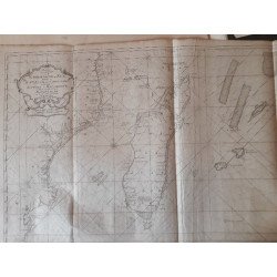
Title: A Chart of the Western Part of the East Indies
Subtitle: with All the Aejacent (sic) Islands from Cape Bona Esperanca to Cape Comorin
 Delivery policy
Our remailer uses DHL/Fedex at a fraction of the standard cost. Email us for a quote.
This attractive and scarce chart of the western part of the East Indies by John Seller was first published 1675 in both his English Pilot (Part Three) and Atlas Maritimus (the latter not reported in Tooley). The imprint reflects a 3-year period in the almost century-long publication history of Seller’s maps. Only one example of this state of the map has been sold since 1985; the Quatar National Library has a copy.
This chart and its decorative elements are similar to the 1654 chart by Pieter Goos (Norwich #244). However, the ships have been omitted but Seller's appeal to the East India Company is prominent: a dedication to the Company added to the left of the title cartouche, to which Seller added its coast of Arms above (Deus Indicat rendered as Deus Indeat).
John Seller (1632-1697) was ‘colourful’ and hugely influential in English mapmaking, with some of his maps and sea charts being published for almost a century by various successors. The title cartouche of Seller’s original state of this chart was amended to include the names the individuals who joined him in a short-lived partnership (1677 – 1679) that attempted to rescue Seller’s struggling business. When the partnership disintegrated, Seller lost publishing rights to Fisher and numerous plates to both Fisher and Thornton – including the plate to this chart.
In about 1700, John Thornton re-engraved the chart omitting the dedication to the East India Company. His plate went through further amendments and, finally, Mount and Page, who acquired the rights of Samuel Thornton inter alia, re-engraved the chart again and included the Mount and Page imprint (Norwich’s Maps of Africa #278).
Soon after the first publication of Seller's chart, Francis Lamb, the engraver, added the Islands of Bombay and nearby the cross of St. George, which are seen on this example of the chart, and included in the edition of the Pilot published together with new business partners and from from which this example of the chart was excised.
The Islands of Bombay had assumed importance in 1668 after King Charles II leased Bombay and adjacent islets to the East India Company for £10 per year. The islands were merged though landfill in 1845 and are now included in the southern part of Mumbai City.
Seller included in the south-east corner of the chart the small south Atlantic islands of St. Paul and Amsterdam. These were important landmarks for Dutch mariners who used the faster Brouwer route to the Spice Islands, a route largely shunned by the English. Failure to head north at the islands sometimes resulted in shipwrecks on the west coast of Australia. Seller might well have included these islands because they were included in Frederick de Wit’s similar ‘Occidentalior Tractus Indiarum Orientalium’, also published in 1675.
This example of the chart is uncoloured and printed on firm paper. The margins are narrow, but the plate lines are still present. It is in fine condition.
References: Tooley’s Collectors’ Guide to Maps of Africa, p. 106-107.
Publisher: London, Fisher, Thornton et al
Dimensions: 55.2 x 43.0 cm.
Date: ca. 1678
Estimate: $2000 - $3500
Reserve: $1750
Author: John Seller (J. Seller, J. Colson, W. Fisher, J. Atkinson & J. Thornton).
Title: A Chart of the Western Part of the East Indies
Subtitle: with All the Aejacent (sic) Islands from Cape Bona Esperanca to Cape Comorin