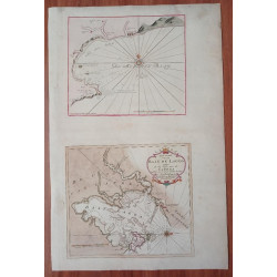
Title: Carta Particolare che Comincia con il Capo Degortam e con il Capo Buona Speranza e Finisce in Gradi 27 di Latitudine Australe.
Subtitle: La longitudene Comica da l’Isola Pico d’ Asores | di Affrica Carta XI
 Delivery policy
Our remailer uses DHL/Fedex at a fraction of the standard cost. Email us for a quote.
Description:
[Special Map from Cape Degortam around the Cape Good Hope to 27 Degrees of Southern Latitude.]
The scarce second state of the landmark sea chart of southern Africa by Robert Dudley. The chart was the first printed sea chart (1646) by an Englishman (who was living in Italy). It was published in Dudley's Dell' Arcano de Mare (Mystery of the Sea), “the first sea atlas in which every chart was based on Mercator’s projection, the first to show prevailing winds and currents in the main harbours and anchorages, the first to give magnetic declination, and the first sea atlas by an Englishman.” (Tooley, p. 43 – see below).
This example of the map includes LoSo at the bottom the subtitle which indicates that it came from the scarce second (1661) edition of Arcano del Mare – the only change to the copperplate being in the subtitle. There is no record of sale of this second state of the chart – there is a copy in the National Library of Australia.
The map was engraved by Antonio Francesco Lucini. He included (inaccurate) coastal profiles of notable landmarks for navigators sailing along the southern African coast.
The prime meridian of the chart is the Azores. The chart is remarkable for showing the Agulhas Bank. The annotation ‘Var Nulla’ south of Cape Agulhas (Cape of Needles) confirms that there was no magnetic variation at this Cape: magnetic north was the same as true north – arguably the first sea chart to show this.
Robert Dudley (1574-1649) had a colourful background. He was the illegitimate son of the Earl of Leicester, the favourite of Queen Elizabeth I and brother-in-law to Thomas Cavendish. In 1594 Dudley sailed with Sir Francis Drake and later received a knighthood for his part in the Earl of Essex's raid on Cadiz. Dudley settled in Florence, and he was in naval service to the Grand Dukes of Tuscany.
The map is uncoloured, printed on firm paper and in near-fine condition: some light offsetting, and also light foxing at the left and right borders. In this second state of the plate, the impression at the map borders is lighter than in the first state.
References: Norwich’s Maps of Africa #245 (first state); Map Collectors’ Series No. 61 # 135;
Publisher: Florence, Giuseppe Cocchini Tooley’s Collectors’ Guide to Maps of Africa, p. 43.
Dimensions: 74 x 47 cm
Date: 1661
Estimate: $5000-$7000
Reserve: $3850
Title: Carta Particolare che Comincia con il Capo Degortam e con il Capo Buona Speranza e Finisce in Gradi 27 di Latitudine Australe.
Subtitle: La longitudene Comica da l’Isola Pico d’ Asores | di Affrica Carta XI